|
|
|
|
|
kings canyon sierra traverse - august 2001 |
back to backpacks |
|
6 days: 85 miles kings canyon national park, california august 1-6, 2001 |
|
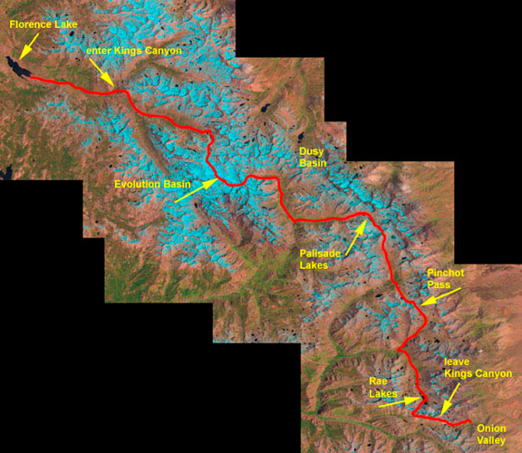
The flight to SFO was without delays or problems (a miracle). We got white gas at REI, bought cheese and squeeze parkay at the Pak-N-Save then drove our rental car to Fresno where we stayed at the Best Western Garden Court Inn. We had dinner at the Old Spaghetti Factory (which wasn't so good). Then we returned the rental car at the airport and caught an expensive taxi ride from Fresno Airport back to the hotel ($16 for 7 miles). This is the route we took from the end of Florence Lake out to Onion Valley. We followed the John Muir Trail for all but the first and last few miles. Our original goal was to hike out on Whitney, but we fell a few miles behind schedule which translated into being a day behind. Positioning yourselves with respect to the passes is important to consider when weather is uncertain. We opted to hike out one trailhead earlier (Onion Valley) to cancel our shuttle reservation.
day 1: florence lake to colby meadow 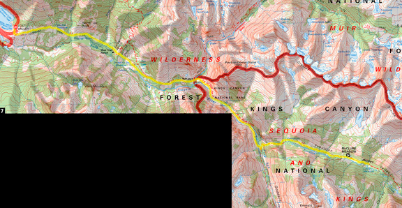
In the morning we took a hellish cab ride with the yellow cab company from Fresno at 4:45 am up to Florence Lake Ranger Station by 7:30 (including a few wrong turns because our taxi driver was a moron among other things). We got our permit and then continued to Florence Lake where we thankfully took leave of the cab driver and purchased tickets at the general store for the ferry ride across the lake. The shop carries all sorts of knick knacks and useful camping and backpacking merchandise plus tourist stuff like t-shirts. The ferry cost $8/person and there were nine of us crossing. Two elderly day hikers (very nice) and one middle-aged solo backpacker (also very nice) and four guys ranging from teenager to adult who were also backpacking. The adult males seemed a little dorky and not that well informed. The lake is dammed at the northwestern end and the water is very clear. It is a lovely place and the sun was quite strong by the time we started across the lake (at 8:30). The elevation is 7328 ft and we reached the other side by 9:00 am. Here we applied sunblock and began to hike at 9:10 am toward the Kings Canyon boundary. 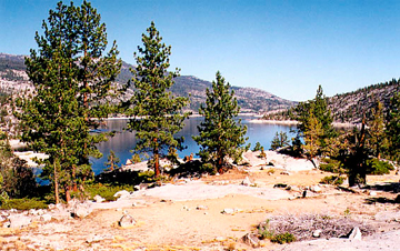
The trail rises above the lake and it is dry and dusty and intermingles with the "road" that a vehicle uses to supply the Muir Trail Ranch. At the junction with the Muir Trail Ranch Trail (you'll know it when you see "No Trespassing" signs declaring private property) and the Kings Canyon trail, we followed the Kings Canyon trail which is higher and gives better views of the region. We reached the bridge into Kings Canyon at 1 pm, 8 miles after starting from Florence Lake. Jeremy stands by the sign for Kings Canyon. He's happy because his pack is light! 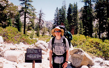
A couple we had met earlier on the trail stopped here for a long break and we pumped water from Piute Creek (which was cold and delicious). We continued through Aspen Meadow and then took a break for lunch. Next we climbed up the trail to an intersection where we turned up Evolution Valley (which is not the same as Evolution Basin). The elevation and the rotten taxi ride up began to take its toll and we slowed down on the switchbacks leading up to a stream crossing. This was Evolution Creek and traditionally in early season it is chest high. As it was, we crossed in tevas and the water got about as deep as your thighs. After wading across, we stopped on the logs for a snack. We were tired, but the cold water had a rejuvenating effect on the feet. We encountered a group of adults who had come down from Darwin Bench (the woman had such a heavy southern accent that I thought at first she was saying Darwin Bitch). They stopped to change footwear before the crossing and we continued to climb onward to Colby meadow. Here we stopped at 7:30 pm and picked a campsite on a small rise to catch any breezes to reduce mosquitoes. South of our site was a large golden meadow surrounded by trees. The creek meandered through the tall grasses and so we endured a moderate mosquito presence that evening. We hiked about 17 miles.
day 2: colby meadow to big pete meadow 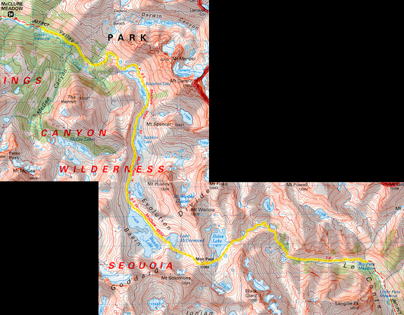
In the morning we felt quite tired and got up at 6:00. It took a little while for us to sort ourselves out, but we were under way by 7:20 am. The trail was mellow for the first bit and we hiked under the shade of the Evolution Valley wall and the trees. In less than a couple of miles we began a set of switchbacks that climbed out of the valley, giving us great views as we climbed toward the lip of Evolution Basin. We met two men - brothers from England - who were hiking the southern half of the JMT. They had done the northern portion last summer and were back to finish the trip. They told us they wanted to hike the JMT before George Bush signed away our national parks to the oil companies. It was embarrassing to hear what an idiot the entire European community thinks he is, but then again, we feel the same way about Bush. A mule train passed us while we rested to remove layers. It turns out that this mule train was an outfitter who carried all of the supplies for some Sierra Club hikers. I can't help but feel that this is cheating and extra damaging to the backcountry. I wonder that Sierra Club members would not be more sensitive to the wilderness they supposedly protect and this is just one of the many problems I have with that organization. Evolution Lake (10,852 ft.) is spectacular. Below: views looking northwest and south. 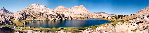
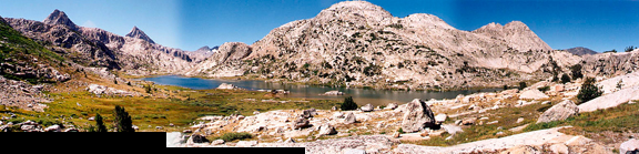
The basin is glaciated, elongate and gentle in gaining elevation. There were a number of people camped along the shores, including the Sierra Club crew. A fellow on the trail said he had camped at the southern end of the lake and now, heading north, said that he should have hiked a few miles further to the north because it is just perfect. We took a quick break for sunblock and food. Then we hiked along the edge of the lake on a nice sandy trail. There was an abundance of vegetation along the lake shore and small bunches of brilliantly-colored wildflowers nestled in the shelter of granite boulders. We were passed by a couple packing very light (we wondered where they kept their food!). The stream crossings were in low flow, but even so, they were facilitated by the careful placement of large rocks across the water. Here is a picture of Jeremy crossing the inlet stream above Evolution Lake. 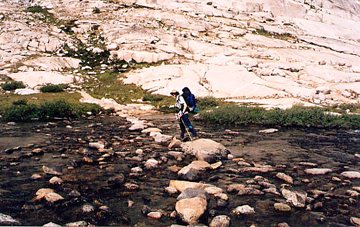
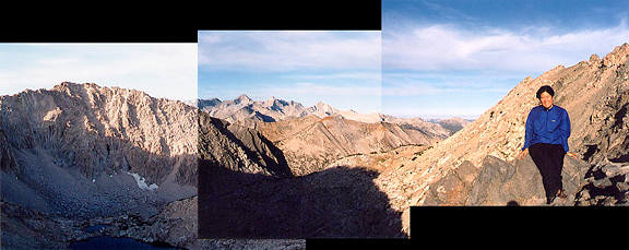
We continued on past Evolution Lake to a few smaller lakes above and then to Sapphire Lake (10,966 ft.). The basin became more barren as we approached Muir Pass. At Wanda Lake (11,426 ft.) we took a short break on the shore for lunch. In the distance you could see Muir Pass. The approach was ever so gentle until the very end, and even that was pretty mellow by pass standards. You could even make out the stony hut at the Pass if you knew what to look for. The sun was bright and the breeze was cool. There was not a cloud in sight. Up the trail to Muir Pass we met a solo hiker who was on his way down from Muir Pass. Once there we took a quick look around the hut (inside is very dark and cool, but we opted not to go in). Here's Jeremy standing by the Muir Hut on the pass. 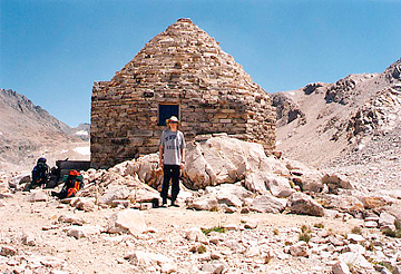
Here I am on Muir Pass with Evolution Basin behind me. There were many marmots poking around in the rocks - bold marmots. Over the other side we could not see our route for very far because it wound around the bend. Small clouds were beginning to form and it was 2 pm. We ate a powerbar and began the long descent down from Muir Pass. The trail was rocky and considerably steeper on this side. We passed Helen Lake and decided to stop further down to pump water. The rock was dark metamorphic rock which enhanced the heat from the sun (and the lack of a breeze). We encountered a solo hiker on his way up to Muir Pass - he looked like hell. He asked how much further he had and we felt bad telling him he had another mile and a half to go. That didn't sound so bad unless you consider it was over 1000 more feet and the clouds were starting to pile up. We stopped at a stream crossing to pump water and soak our feet. The cold water helped reduce swelling and get your mind off of the ache in your feet. We snacked on dried fruit, salami and cheese then took a long swig of freshly pumped water. Our new platypus hoser systems worked fabulously! We could pump water directly into the bladders without ever removing them from our packs. The only drawback to the hoser bite valve is when you eat food and try to drink at the same time - it takes some practice to avoid getting food sucked back into your hose. 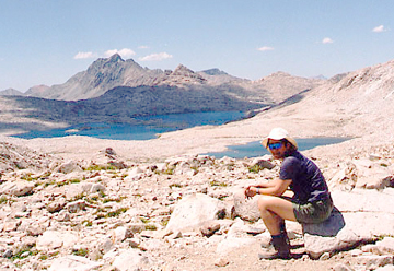
Once on our feet again, we descended to small patches of trees along the way. There are some lovely camp sites among the trees between 10,800 and 10,400 ft. We passed the two British brothers at the southern end of the tiny lake, camped out and getting ready to make dinner. The trail was still steep, but we rambled in and out of shade from the trees and a breeze began to pick up again. At 5:30 we stopped to have dinner off the side of the trail. We had spelt (substituted for macaroni) and cheese. Interesting pasta, something you could get used to. After dinner, we packed up and moved further down the valley in search of a camp site. We passed through a drift fence and came upon Big Pete Meadow where we decided to camp past a stream crossing at 6:45 pm. In the meadow were the mules and horses from the outfitter's mule train. They ran loose and grazed and frolicked in the evening - we could hear the bells on the two horses jangle as they trotted about. They came down the trail and passed near our camp many times and it was nice. We washed out our sweat rags and t-shirts and then set up camp, ready for sleep. There were mosquitoes about, but they were not aggressive. It was almost a full moon and all night long about every hour, the horses and mules would visit us in camp. We actually liked their company. No signs of bears.
day 3: big pete meadow to palisade lakes 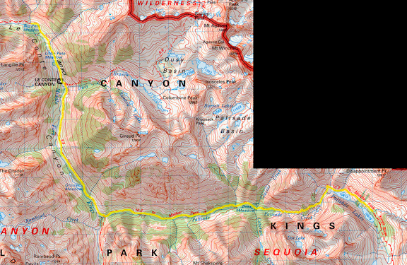
From our camp, which was heavily trafficked by friendly pack animals all night, we left at 7:15 am and hiked down the valley toward Little Pete Meadow. The hike down was moderate in steepness and quite pretty. We passed through bouldered grassy fields in the shade of the valley wall watching the line between sunlight and darkness creep across the valley floor. While we hiked along, we waved to at least 6 camps with people in various stages of their morning rituals. Some campsites looked very buggy (that's what happens when you camp in a bog) and some were so full of junk, we couldn't figure out how these people carried it all in. Here's a photo as we approached Little Pete Meadow from Big Pete Meadow. 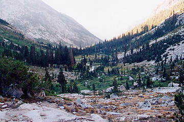
Once we passed the Dusy Basin junction the valley became soggy and a little buggy. We maintained a fast clip through Grouse Meadows and arrived at the turn off leading to Deer Meadow. There was a nice high hump (with a good campsite) that received a nice breeze. We stopped here to apply sunblock and have a snack. The couple carrying no more than what looked like overfilled fanny packs passed by as did a couple with their two young daughters. We descended to the junction where Palisade Creek and the Middle Fork of the Kings River (what we followed down) meet. There were many campsites here and plenty of mosquitoes too. We took a quick glimpse at the map and proceeded up the valley heading east. This part of the trail sucks. I mean, hot, buggy, wet, overgrown - it sucked like this for about four miles. The vegetation finally started to open up and we came upon a campsite in Deer Meadow where we stopped for lunch. This area was shady and breezy which kept the mosquitoes at bay. We pumped water from nearby Palisade Creek and then quickly rose out of treeline into stunted trees and shrubs. Here is the view of Deer Meadow from above. Behind and to the right of the right side of the valley was where we turned off from the Middle Fork of the Kings River. 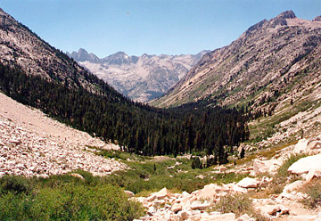
We were now on switchbacks approaching the Golden Staircase. The sun was so intense that we expected it to be very hot, but temperatures were milder than usual and the steady breeze made the climb comfortable. Here I am next to the small waterfall that drains the Palisade Lakes and feeds Palisade Creek. Shortly after the photo we encountered four trail maintenance crew strung along the trail on their way down. 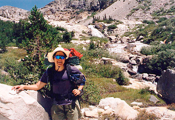
This is where the Golden Staircase steepens. We had actually begun it after leaving treeline, but didn't realize this at the time. The sets of well-maintained switchbacks wind through occasional patches of trees which provided fantastic shade for rests and views of the magnificent valley below. Tiny clusters of brilliantly colored wildflowers danced in the breeze along the trailside. The trail is not the hardest we have encountered in the Sierra, but it is special because of the engineering involved (once again, blasting a trail into a cliff is pretty awesome). This was the last segment of the John Muir Trail to be completed and if you look at the terrain and the nearest trailheads (both at least 2 days away and over the eastern Sierra escarpment), you will understand why. It was beautiful. The picture shows the beginning of the ascent. 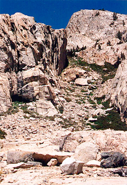
Hiking up to the bench where the first of the Palisade Lakes rests reminds me of why I love glaciated terrains so much. Rounding the next bend, coming up over the lip of a bowl - it affords such breathtaking views, always a surprise. After climbing up one switchback after another, the trail leveled out gradually and we arrived at the lake. There were a few campsites along the northern end of the first lake, and the trail hugs the shore half way and then begins to climb. We still had energy and opted to hunt for a campsite further on. This is a view of the first lake from the trail. In the distance to the left you can see the second lake. The difference in elevation between these two lakes is 66 feet. 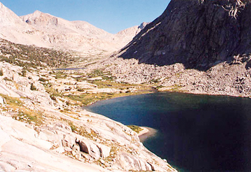
For some reason I thought that the trail would drop down between the two lakes and follow the shore again, but it never did. The trail rose about 40 feet above the water along the boulders where there were few good campsites in view. As we hiked, we heard and Jeremy saw the tail end of a minor rockfall on the southwestern walls of the second lake. The sound was incredibly loud considering the magnitude of the fall (pretty small!) We hiked halfway along the second lake before finding the first really nice campsite. We dropped our packs here and Jeremy ran ahead to see how much further water was (it was less than 100 feet). The couple we had encountered as we entered Kings Canyon hiked up a minute later and camped nearby. It was only 5:15 pm and we had plenty of time for washing out stinky clothes, washing ourselves, eating dinner and relaxing. Here is a shot of camp. The lake is down to the right. 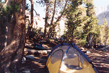
day 4: palisade lakes to south of twin lakes 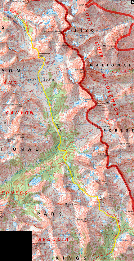
Each morning we managed to rise a little earlier than the previous morning and get a nice start. This day we were hiking by 6:30 am. Early starts are cooler which is nice when you want to avoid bugs and heat and the sun. Valleys in particular offer shaded protection from the sun for a little time after skies brighten. This is a picture of Mather Pass and the ridge bordering the basin to the south. (Taken the day before from camp.) 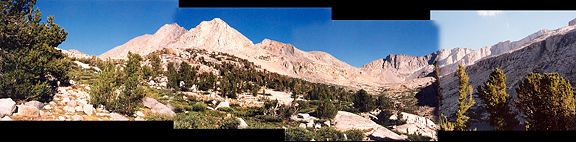
The trail gently climbs above the second of the Palisade Lakes and then begins to switchback through granitic talus up to Mather Pass. It was a couple of miles to Mather Pass (12,000 ft.) from our camp and we remained in shade until the very top. Here is a picture of Jeremy just off Mather Pass with unnamed lake 11,320 and the Palisade Lakes basin behind him . 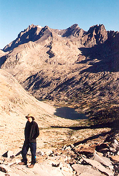
Here is the view south from Mather Pass, named for Stephen Mather, first director of the National Park Service. Regretably, this was the last photo I could shoot for the day. At the end of my roll, the film snapped from the cannister and I could not rewind without opening my camera (and killing the film). It really was unfortunate because Upper Basin - pictured in the foreground - all the way to Lake Marjorie and over Pinchot pass are incredible places to walk through. In the late afternoon, we would be crossing the ridge in the far distance. 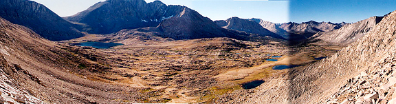
The descent down from Mather Pass to Upper Basin was a little steep then it mellows out. We heard someone hooping and hollering in the basin below, but couldn't see any obvious camps. We met a solo hiker on his way up to the pass. We exchanged greetings and I asked how he was. He replied, "I'm fine. What am I saying? I'm great! It's awesome here!" We figured he was in such a happy state that perhaps he was the one moved to holler out loud from below. We trucked along through Upper Basin which is dotted with tiny lakes and grassy meadows. It has a subdued topography - mostly flat with a few rolling bumps - lots of granite boulders strewn about and as you lose elevation more islands of stunted pines appear. Really lovely. At the low point (10,000 ft) 6.5 miles from Mather Pass, we crossed the South Fork of the Kings River and stopped for lunch. The water was very cold and there were nice deep, blue pools along the river. We sat on a broad slab of granite in the sun to pump water and soak our feet. There are campsites here and plenty of shade, but we were just visiting. Two fellows hiked from the trail we had come down and stopped to pump water. We waved to each other and they continued up the trail. One was decked out mostly in red clothing and red gear. The other was predominantly swathed in blue. I referred to them as Thing One and Thing Two and I think THEY were actually the hooting and hollering we heard. As we packed up to leave, the couple that camped near us the night before was just arriving to take a break. We waved and that was the last we saw of them. The hike out of the valley was dry and wooded. It went quickly for us and we popped out of the trees at a junction near a small unnamed lake and an unmarked backcountry ranger station. We hiked through the subalpine terrain passing more random lakes and eventually rose over a bench to beautiful Lake Marjorie. The trail rambles along the shore and we passed Thing One and Thing Two taking a break near a tree. We pushed on to a high stream crossing to fill water and then made our way to Pinchot Pass. Somewhere near the pass, the rock underfoot changed from light colored granite to a darker metamorphic rock (it was hotter under the sun and harder strengthwise). We encountered a father and son on their way down from the pass. Once over Pinchot (3:30), we dropped quickly into the basin. I guess it is a pretty basin, but I didn't feel that way at the time because I was becoming footsore and tired. The trail levels out and wanders down to treeline where it steepens. Once we passed the Twin Lakes we began searching for a campsite. Thing One and Thing Two caught up with us and we paused to chat. They were hiking the JMT and had some funny stories to share - really pleasant, easy going guys. We hop-scotched with them a few more times before we found a mediocre campsite just after crossing a tributary to Woods Creek at 6:00 pm. This was a buggy site and we were harrassed as we ate.
day 5: south of twin lakes to rae lakes 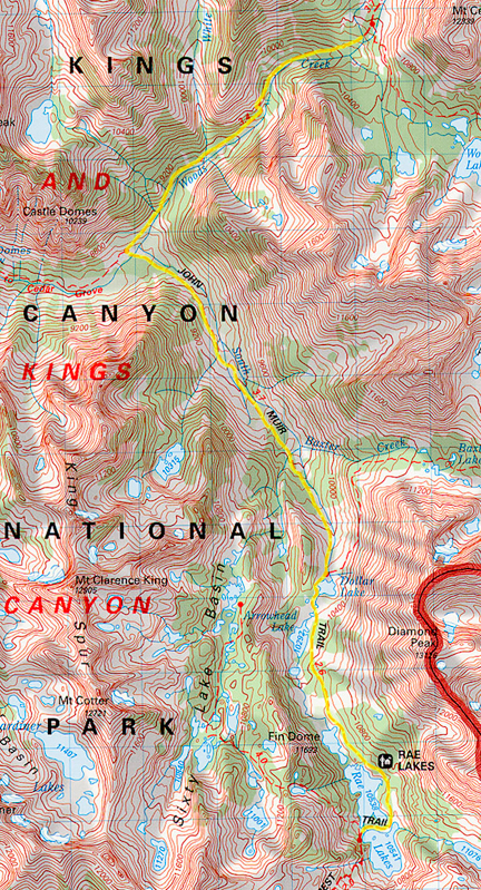
I woke in the middle of the night and saw that our tent was casting strong shadows across the floor due to the brilliant full moon. I was groggy, but remembered to open my camera under the sleeping bag and manually rewind the broken film and plop it into a secure cannister. Pictures would resume that day. Camp was cold and windy that morning and we were hiking by 6:40 am. The trail descended alongside Woods Creek and we saw no other campers, mostly because there were few good places to camp. Eventually we passed the site where Thing One and Thing Two were just getting dressed with bear bags still intact. That was the last time we saw them. At the junction (and our turn off), we crossed Woods Creek one last time to follow the JMT. Below is the very bouncy, very fun and impressive suspension bridge over the Creek. Cross one at a time! 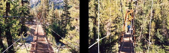
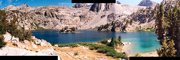
We stopped to pump water and have a snack. A couple of groups had camped there (lots of campsites) and were just starting up the way we had come. Lathering up with sunblock, we shed our layers and made ready for the ascent up to the famed Rae Lakes. I had always wanted to visit those lakes and had only one botched attempt in 1996 (Jeremy got very very sick on the trail) - this time it was just an added bonus to our already special trek across Kings Canyon. I cannot say that I enjoyed the hike up the valley much. It was better than getting to Deer Meadow, but the rolling nature and the overgrowth was still annoying. We encountered more hikers coming down the trail including one dork who said to watch out for Grizzlies. Keep in mind that he was shirtless with a giant tatoo on his gut that read "Fuck ---". I couldn't make out the bottom word and wasn't really interested in pursuing it either. I told him he was thinking of the wrong range. We got to Dollar Lake and decided to move on to Arrowhead Lake where we stopped for lunch and water in the shade of a campsite. It was very peaceful there and someone was doing Tai Chi exercises in a meadow on the shore (although he was doing it way too fast). On our way up the basin we were stopped by a backcountry ranger. She asked to check our permit and warned us of bear activity and was very friendly. So far in the season, the bears were being good and the backpackers were all using bear cannisters. She said there were some very large bears in the area too. We moved on to the Rae Lakes where it appeared everyone in the basin was involved in a massive party. Someone had brought an inflatable raft and half naked people were swimming or diving off of rocks into the lakes. It looked so inviting! We eventually found a campsite at the edge of the second lake - it was only 2:30 and we debated shooting for Glen Pass. We agreed to relax and enjoy the lakes. Below: the Rae Lakes looking north and south. 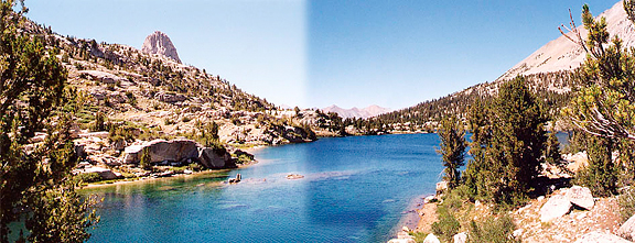
In camp we pumped water, washed up, hung clothes to dry and lounged in the shade. We found some trash someone had left at the base of some trees. It included a Mountain House wrapper, batteries, and lots of other crap. I was pretty furious as was Jeremy. We didn't really have room to pack it out, so we took anything that might be attractive to a bear and put it with our food trash to pack out. The rest we wrapped up in the giant trash bag they also left behind. By 4 pm we could see some wisps of high clouds accumulating in the sky. We went to sleep just as the sun was setting and could hear a lot of singing and shouting from the throngs of people camped by the first lake. I was glad we weren't camped there. 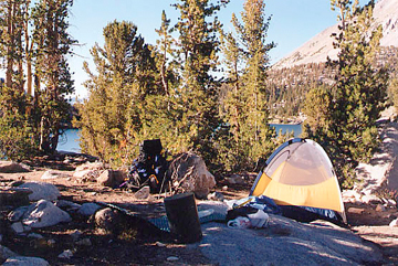
day 6: bullfrog lake to onion valley 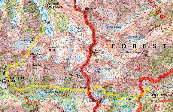
We rose early in the morning and were underway by 5:45 am. After we hiked across the small stream crossing we saw a sign posted showing campsites in the Rae Lakes area and a sign that prohibited camping between the lakes (where we had essentially camped). It would have been nice if they had posted that on the OTHER side of the lakes too. The other trail at this junction led to the Sixty Lake Basin over the western ridge of the Rae Lakes basin. We climbed switchbacks rising above the lakes for about 800 feet before we arrived at a bench that cradled a dozen small lakes. There were a few camps along the rock shores of the lakes. The skies were overcast with a thin blanket of high clouds that occasionally obscured the rising sun. From here the switchbacks led up a wall of talus to the pass. The image below is what we saw before starting up to Glen Pass. 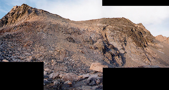
The last switchback to Glen Pass reminded me of the approach to Kearsarge Pass (which we would do in a few hours). We made Glen Pass by 7:45 am and stopped to refuel (snack) and take some pictures. The sun came out from behind the clouds, but over the pass we could see there were more in the distance. Here is a picture of us on Glen Pass (pointing NW) and looking south from Glen Pass. 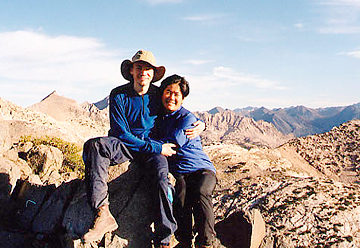
Coming down from Glen Pass into the narrow basin, we realized that it was our dumb luck to have pumped water before going over the pass. The small lakes we saw on the map were not easily accessible from the trail and the water levels were low, leaving dark rings on the surrounding rocks. At some point, we heard an enormous explosion of some sort. It wasn't thunder as far as we knew, so we assumed perhaps a sonic boom. We began to encounter hikers once the trail rounded the bend and we could see Charlotte Lake down below. Many asked how far it was to Glen Pass and if there was much bear activity at Rae Lakes. When we got to the junction for our turnoff we paused to consider pushing for Forester Pass and finishing the JMT by the next evening. Hiking that kind of milage and elevation is great if it is optional, but when you are under such tight time constraints, it is no longer vacation. Part of what I love about backpacking is the ability to be flexible, and I didn't feel compelled to finish the JMT on Whitney. It would be left for yet another Sierra trip - icing on the cake. We agreed to hike out to Onion Valley. Just then, a fellow wearing sandals(!) asked us if the trail leading down the valley was the JMT and that he was hiking the JMT. I replied yes and marveled that people would venture into the backcountry for that long without a map. We took the higher of two parallel trails that lead to Kearsarge Pass. Below is Bullfrog Lake in the bottom left and in the far distance is the Kings-Kern Divide (looking south). 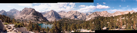
On our way up to Kearsarge Pass we met more backpackers on their way in. We even chatted with one fellow who had a pack about as big as himself. His sleeping bag was almost as large as my entire pack. He had every known electronic gadget dangling off of his person. He was on a two-way radio with a buddy of his. We commented on the monsoonal system that was developing and he said that according to his weather radio which picks up current satellite weather data that it was typical for the Sierra and nothing to worry about. Having seen this exact monsoonal pattern last year and knowing what the "typical" Sierra pattern is, I figured he was an idiot. People, new fangled toys are not a substitute for brains! We stopped at Kearsarge Pass just long enough to let other hikers pass before leaving beloved Kings Canyon. On the trail down, we encountered what seemed like a highway of hikers. One guy stopped us and asked us about the Big Bang and the age of the universe. Luckily for him, we had an expert (Jeremy) to answer his many questions. How nice to find a random guy on the trail who - in his 40s - wants to learn more about science. As we hiked, our thoughts turned to the logistics of getting from Onion Valley to Lone Pine. We had already decided that I should approach people about hitching a ride since I'm female. We reached Flower Lake and three female day hikers told us trail crews were blasting and had instructed them to wait at Flower Lake until about 12:30. We thanked them and hiked a little ways down to get to a stream to pump water. We met a trail worker on the trail who asked us to stay above him until the last charge was detonated. He had an attractive and well-behaved German Shepherd with him too. The blast caught us by surprise despite the fact that we were expecting it! So that's what we had heard after we crossed over Glen Pass earlier in the day. He radioed his coworkers and informed us it was safe to proceed. We hiked quickly although our feet were feeling very badgered. I guess because we were anxious to hike out, we didn't take care of our feet the way we usually do. Once beyond the bounds of the John Muir Wilderness, the trail was dusty and we could see the parking lot below. Just as we reached the trailhead at 1:15 pm, I saw a couple walking from the trailhead to their car. I wanted to take a picture, but opted to take the opportunity to ask for a ride to Independence. They seemed reluctant at first and I told them saying "no" wouldn't hurt our feelings. They managed to fit our packs into the tiny trunk space (another reason to pack light!) and we squeezed into their tiny 2-door car. After we found out what nice people they were, they then asked where we were headed beyond Independence and offered to take us to our motel in Lone Pine. They gave us their mailing address and phone and asked us to call them next time we visited the eastern Sierra. It always feels good when you hike out, but it was especially good to have made two friends who love the Sierra as much as we do. |
|
|
|
back to backpacks |
