|
|
|
|
|
mount whitney - september 2003 |
back to backpacks |
|
5 days: 60 miles john muir wilderness/sequoia national park, california september 6-10, 2003 |
|
They say the third time is a charm. On two previous trips, we had tacked Whitney on the itinerary as "icing on the cake": Kern Canyon 1995 and Kings Canyon 2001. Kern was supposed to be a 14 day trip which was truncated to 8 days after we tired of being mosquito fodder. Kings suffered from overly ambitious mileage and falling a few days behind schedule. Most of our jaunts in the Sierra have ignored Whitney's presence, but this time we were flirting with the Whitney Zone. We could at least give it a try. They say the third time is a charm...
day 1: horseshoe meadow to rock creek crossing We started at 7:20 am while most of the other campers were waking up. A group of about 20 students were hiking out as we set off into the backcountry. The trail out of Horseshoe Meadow is sandy and littered with horse and mule poop. As our luck would have it, a rainstorm had passed through two days ago and the trail was still moist and packed. Further up toward the pass, the sand was less consolidated. Reached Cottonwood Pass by 9:30 and took a break for some food. On this trip, I paid close attention to stomach grumblings and fed it even though I had no appetite. It really helped me maintain my energy levels. On to Chicken Spring Lake to pump some water and muck around in the marshy parts. We wore trail runners on this trip. The main disadvantages of trail runners to boots are 1) serious cross country runs higher risks of injury and 2) your feet get wet. 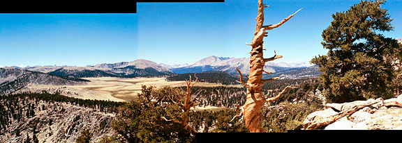
Above Chicken Spring Lake we saw familiar vistas like Big Whitney Meadows, Siberian Outpost, the Great Western Divide and the Kaweah Ridge Range. This is Siberian Outpost to the west. Beyond the lake the trail contours around arm after arm finally reaching the high point just above a bowl. We lunched at the bowl and met three fellows hiking out from their 7 day trip to Whitney. 
More contouring eventually brought us to the long sought boundary between Inyo National Forest and Sequoia National Park. I should note that the trail up to this point sort of sucks because it is sandy. We decided not to return this way, but to return via New Army Pass. The extra 1000 feet was worth it for a good solid trail. At the junction with the PCT, we turned west, skirting the edge of Siberian Outpost on a mostly level plateau for much of the way. We then switchbacked down to Rock Creek, past the ranger station. There was a very nice site just beyond the ranger station, but we wanted to get a little further. Near the Rock Creek crossing we settled for a streamside campsite at 4:50 pm.
day 2: rock creek crossing to guitar lake In the morning, I retrieved the only item we stored in the park service bear box, our empty cookpot. Mice (who are incredibly talented at wriggling through the tiniest of holes) managed to visit the bear box in the night and proceeded to nibble at the plastic bag and poop all over it and the cookpot. Good thing we brought both of our bear cannisters. We washed the pot carefully making sure to sterilize it that evening. Mice have been known to carry nasty things like the Hunta virus. We started at 7:30 am and began ascending to a series of flats which we referred to as flateaus. Once over an unnamed saddle by 9:15, which is commonly called Guyot Saddle, we dropped down to Guyot Flat where we took a mid morning break for more food. 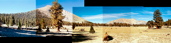
From the flats we had nice views across to Red Spur on the Kaweah Ridge Range and also Chagoopa Plateau. The air temperature was cool, but not uncomfortable. The trail did more of the up and down until we descended somewhat steeply to lower Crabtree Meadow. Below is a picture from above Crabtree Meadow looking east toward the Whitney Crest. Lower Crabtree has wonderful campsites along the creek, although in peak mosquito season, this would be hell on earth. We crossed the stream and hiked on to Crabtree ranger station where we took a break to soak our feet in the icy cold waters (reduces swelling and feels sooo good), eat lunch and rest. 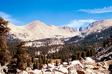
After lunch, we climbed from Crabtree Meadows over a number of benches in the basin west of Mount Whitney. Timberline Lake was very pretty, but at the time we weren't interested in pretty alpine lakes, we wanted to get to camp. Eventually Guitar Lake unfolded before us and we headed to the eastern end in search of good sites. We settled on a bench beside the lakeshore although we were debating whether or not to shoot for the tarns above the lake. Alas, two other backpackers passed our site and set up camp on the tarn. It was 3:15 pm and we had plenty of time to wash up, eat, clean gear, and roast in the relentless sun. I kept looking toward the crest. Looking for the trail and thinking I could catch segments of it on the talus. Wondering if I would have the energy to get up there the next day. And where the heck was Whitney anyway? I couldn't identify it (that was because it was obscured from view). Fish splashed on the lake as the sun set. 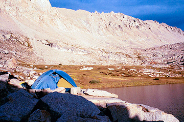
day 3: guitar lake to mount whitney (roundtrip) 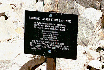
High clouds were strewn across the sky in the morning and we debated the wisdom of attempting Whitney. The clouds did not appear to be accumulating, just wandering past. It was not monsoonal based on their easterly flow. After much (too much) time, we agreed to just head up the trail and see where things went from there. At 7:40 am we left most of our gear bundled among the rocks and set off for the Whitney crest. At the beginning I felt weak, but we snacked and I adopted a slow and steady pace. The air and the winds were cold as we were in the shadow of the mountains. Taking a break at the bottom of the switchbacks, we encountered a backpacker (Vern) who was entertaining and most encouraging. Our spirits rose with the trail and before we knew it, we were at the crest in less than 2 hours of hiking. 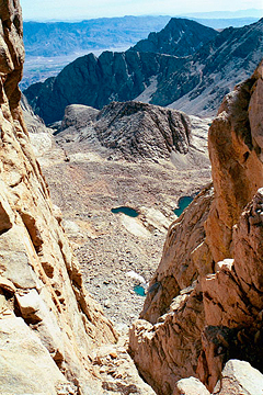
At the trail junction we met with the onslaught of day hikers and backpackers coming from Whitney Portal. Walking the Whitney trail you observe all sorts: the ill-prepared hiker, the elderly woman who is kicking everyone's ass (and has been for years), a fellow wearing tevas, JMTers, young, elderly, fit, unfit, crazy, experienced, determined, exhausted, jubilant. Most backpackers drop their packs at the trail crest. We followed the crest trail out to the pinnacles where wonderfully sheer drops open up before your feet. The views aren't bad either. The trail is incredibly well maintained. I continued on with my steady pace, but felt none of the typical effects of altitude like dizziness, shortness of breath, or headache. We were just amazed as the views got better and better - the entire Sierra sprawling out before us. 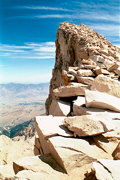
Once around the pinnacles, we crossed to the backside of Whitney and began the last few hundred feet to the summit. All of the peaks and crags that loomed above us so dauntingly from Guitar Lake were now below us. We could see over Mount Hitchcock into the Crabtree Lakes. As we neared the summit, we passed plenty of hikers resting on the rocks by trailside. Rather than slowing down, we were invigorated. The attitudes of most hikers were friendly and hopeful. "You're almost there!" or "Just take it slow" you would hear people tell one another. No one minded stepping aside to let another pass, and plenty of jokes and funny comments were made along the crest. 
At the summit, we could hear some guys near the register congratulating each other. As Jeremy puts it, the summit is one continuous celebration as people leave and more arrive. I turned to him and wished him a happy 30th birthday (one week early). We had always considered Whitney to be an undesirable hike because of the mobs of people, the stigma of being the highest point in the lower 48 states, the overuse. All of that disappeared once we were there. The expanse of the landscapes before you are breathtaking. For us, it was so special to look around and identify the places we had been walking for the past ten years together: the glorious High Sierra. We made summit by noon and lingered long enough for pictures, the register, locating the fire south of Kern, and taking pictures for other folks. It felt good. We felt good and strong, ready to head back to Guitar Lake and leave the mountain to others. Below: view from Mount Whitney looking east. 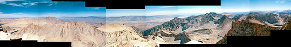
At 1:00 pm we began to mosey down the trail answering people when they asked how much further to the top. I could tell many of the portal hikers were struggling here. They looked so tired - some started at 4:00 that morning and ten hours later they were still over a mile from the top. I liked our route. We had time to acclimate and strengthen ourselves carrying a pack. The dayhike up to Whitney was shorter with more time for solitude and most of all, less elevation to descend. At the junction on trail crest, we bid farewell to Vern who was in excellent spirits and going over to Tent City for the night. I took a picture of Guitar Lake (which really does look like a guitar!) and it was 4:00 pm when we finally arrived at camp. More backpackers arrived and occupied sites around the lake. We opted to stay at the lake for another night rather than packing up and heading down to Lower Crabtree. We slept very well that night. 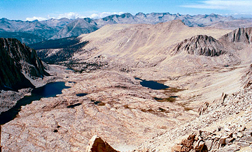
day 4: guitar lake to new army pass-soldier lakes junction Another start at 7:40 am and more high clouds passing overhead moving toward the south. We wished the other backpackers luck on Whitney and started down the basin. Just before Timberline Lake we encountered two large fowl on the trail. I think they are grouse, but they didn't boom like the blue grouse we have seen out of Mineral King. Perhaps they were female or perhaps they weren't grouse at all. Not far beyond the birds, we passed two backpackers on their way up. The clouds were evaporating quickly and the air temperature was cooler although the previous evening had been particularly warm. A cold front was supposed to be moving in. 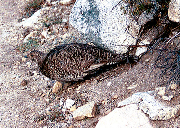
At Crabtree Meadow we pumped water and admired Whitney before setting off for Rock Creek. Between Guyot Flat and Rock Creek, we saw pairs of backpackers and one giant group. At the Rock Creek Crossing (2:00 pm) the campsites were mostly full and there were a lot of tired looking men mooning about. We hiked upstream to another nice campsite where we stopped to snack and soak our feet in the cold water. Ahhhhh. Our plan was to get as far as we could that day. The trail followed Rock Creek at a moderate grade for what seemed an eternity. Under other circumstances I would have appreciated the shade, the breeze, the lovely waterfalls, but I felt pretty spent. We climbed up over three or so benches with meadows until we arrived at Rock Creek Lake at 4:45 pm. It was getting chilly and the sun was moving close to the valley wall. The campsites near the lake were very nice and we were both tired, but I thought we could push on to get to Soldier Lakes before it got dark. 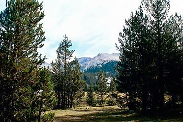
As we crossed the meadow, the winds and cold increased substantially. Once at the base of the bench we were to climb, the trees sheltered us from the chill. From there it was a steep ascent out of the valley - the steepest we had encountered all trip. At the turn off for Soldier Lakes basin, I thought we could make it to the next trail junction just under a mile away. Having been to Soldier Lakes two weeks ago, I knew there wasn't much sunlight left in the day where we could camp. Beyond the junction with the New Army Pass trail, we found some excellent campsites. We set up camp and began to eat at 5:40 pm. The sun lingered long on our site, but when it began to set the winds whipped around and we had to build a small rock wall at the base of the windward vestibule. Later in the night the wind died down - it became very cold. Below: Rock Creek Lake looking towards Miter Basin.
day 5: trail junction to horseshoe meadow Morning clouds were nowhere to be found - it was crystal clear! We were all set to go out over New Army Pass, but did not want to deal with the up and down nature of the last 4 miles to trailhead. At 7:10 am we opted to go back over Cottonwood Pass. It was a matter of sandy trail (Cottonwood Pass) versus rolling up and down (New Army Pass). That cold front had arrived. The morning was the coldest one of our trip and we were in shade for the first few hours. As we approached the Sequoia National Park boundary, we heard a group of coyotes howling and yipping in the direction of Big Whitney Meadows for about 5 minutes. At the high point, we stopped for food and sunblock and shed some of our layers. On our way down from Cottonwood Pass we stopped to chat with a fellow who was hiking to the pass to prepare for dayhiking Whitney the following day out of the portal. The trail was drier than 5 days before and mucking through the sand made the remaining miles seem longer than they were. We finally hiked out at 12:30 pm. Awesome, but exhausting trip. |
|
|
|
back to backpacks |
