|
|
|
|
|
cottonwood pass - november 2002 |
back to backpacks |
|
2 days: 18 miles john muir wilderness, california november 2-3, 2002 |
|
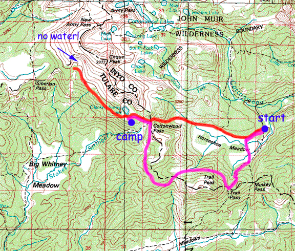
day 1: horseshoe meadows trailhead to chicken spring lake 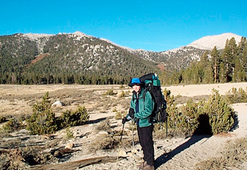
Woke after a rough night of little sleep and the unfortunate but thankfully infrequent wafting from the pit toilets passing by our tent. Overnight low was probably in the single digits since our water partially froze in the tent. We were slow to get going due to the cold (and the fact that my contacts froze in their little nuker). We started from the trailhead at 7:30 am and within the first 1/4 mile were immediately plagued with the frozen water in the hose problem. Sucking drops of water through ice requires a lot of effort at 10,000 feet. Eventually we stopped in the sun, removed the hoses and warmed the ice with our hands until it could be slung out. The trail is sandy and littered with pack droppings, but the scenery was pleasant and the grade gentle. We soon entered the edge of lovely Horseshoe Meadows and skirted the meadows before begining the ascent to Cottonwood Pass. 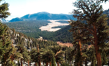
The switchbacks afforded better and better views of the meadows below and also of the surrounding high country. The forests of foxtail pines were pleasant and beautiful, standing among granite boulders strewn across the slopes. We would often come upon inviting little park-like clearings in the woods as we hiked. 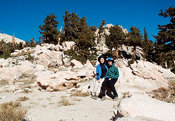
We arrived at Cottonwood Pass and enjoyed the views back over Horseshoe Meadows and across to the Great Western Divide. The sky was a deep blue with only a couple of small high clouds to the southeast. We stopped for food since our energy felt unusually low. I was quick to chill in the cold wind, despite the blinding sunshine. We looked around to identify nearby features on the map (TFITF - this feature is that feature). The gentle slopes of the area made us want to wander into the meadows and just lie in the sun. Below: looking east and then west from Cottonwood Pass. 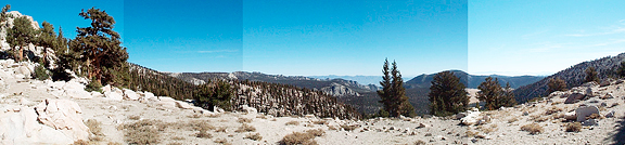
Beyond Cottonwood Pass, we took the trail to Chicken Spring Lake. There is a slight climb in elevation and the path flirts with treeline so that you get great views to the south while enjoying the company of the majestic foxtail pines. As we hiked down to the Chicken Spring Lake outlet, a golden meadow opened up and the smell of willows reminded me of other streams in the Sierra like Lost Canyon and Upper Big Arroyo. The stream was covered in a thick sheet of ice although you could hear the trickle of water beneath it. The plants along the frozen stream banks were yellow or bare. We could see the lake to the north and the nice campsites along the shores. 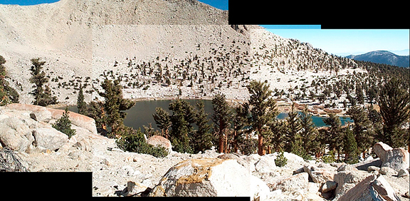
We continued on the trail which climbed up and around the lake onto an arm where the stunning Kaweahs came into view. Here, Jeremy points to the Kaweahs, and to the left you can see Big Whitney Meadows. We followed the trail which rolled along at treeline rounding arm after arm, admiring the mountains, the foxtail pines, and the expanses of open meadows and clearings. At about .5 miles from the Sequoia National Park boundary, we thought it was time to pump more water. The map showed a small lake in a granite bench above the trail. We were in a stunning cirque with a tiny meadow at the bottom and perfect campsites all around. Jeremy went to look for the stream outlet while I watched the packs. He came back with no luck. Then he clambered up to the bench only to discover that the lake bed was bone dry and had been for quite some time. 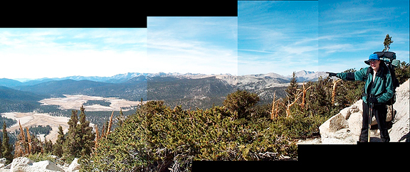
At this point we were both admonishing ourselves for not having thought to pump water at Chicken Spring Lake and for forgetting that this was the driest year on record for California. We could continue ahead into Sequoia in the hopes of finding water above Rock Creek, but we weren't sure if we wanted to spend a lot of time hiking out the next day via New Army Pass. We didn't have enough water to last until the next morning even if we stopped to camp right there. We had not been eating enough and the elevation and lack of food made our progress uncertain. So we decided to head back to Chicken Spring Lake to pump water and make camp with enough daylight to get settled in. Here is an example of the fascinating downed wood of the foxtail pines. 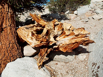
We had not seen many animals except for a handful of skittish golden-mantled ground squirrels and a few birds. Delicate wisps of high clouds were emerging in the sky. When we arrived above Chicken Spring Lake, we selected a campsite above the lake on a low saddle to maximize direct sunlight. Jeremy ran off to pump water while I set up camp. We ate our cold dinner, talked about our options for the following day and readied camp and bear cannister for the night. The sun was still an hour from setting, but thicker bands of clouds moved in and obscured the precious light. The air temperature was cold, although not as cold as the first night. We walked around on the high points near our camp, soaking in the sight of the valleys below and marveling at the resilience of the trees. When it looked like actual sunset, I crawled into my bag and dozed on and off for the next 5 hours. I had to pee 4 times in 3 hours, but it wasn't so bad because the air was still and not nearly so cold (maybe in the teens). The night sky was still brilliant, but there were fewer stars due to the high clouds overhead. 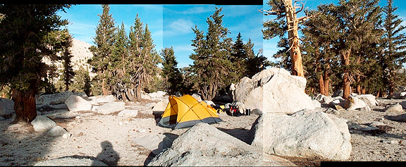
day 2: chicken spring lake to horseshoe meadows via trail pass 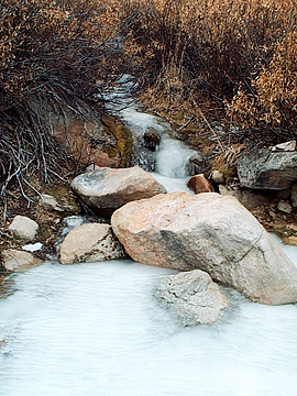
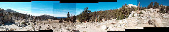
We were hiking by 7 am, and the streaks of clouds in the east made for a delayed, but colorful sunrise. Once at Cottonwood Pass, the desire to hike out as soon as possible diminished. It would be almost double the distance to go via Trail Pass, but that route was appealing and new. So we headed out alongside the meadow to see more of the Golden Trout Wilderness. This trail was spectacular because it hit many small unnamed saddle points, like a tour of mini-passes. Hiking through the sparse forest, every half mile or so you would see the horizon ahead - the trail and then blue sky beyond. All of the saddlepoints were flat with inviting open sandy stretches among the pines. This trail also rolls mildly up and down. Here's the only "water" we crossed - a beautifully frozen tiny fall (and slick as teflon). 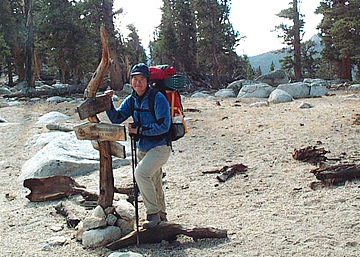
We rounded an arm and passed Poison Meadow which sits on a bench above Horseshoe Meadow, then descended down to Trail Pass (10,500 feet). We took a break to eat more food and catch a last glimpse of the hills to the south where the PCT continued. The air was markedly colder here and remained so. The trail switchbacks down through the trees on soft and sandy ground. We encountered our first hikers on the trip who had a very sweet and cuddly yellow lab with them. We chatted briefly and then continued on our way. When we finally approached the edge of the meadow, the world seemed to open up in front of us. 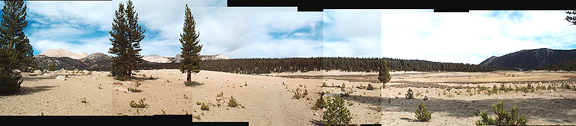
Emerging from the trees, we drank in the view of Cottonwood Pass and surrounding peaks and forests. As we crossed the golden meadow, a steady, cold wind was blowing from the west. Once on the other side, we entered the trees and arrived at the junction with the Cottonwood Pass trail. It was only a half mile back to the car. 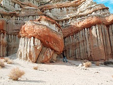
We stopped at Red Rock Canyon State Park off of the 14 out of curiosity. When we had driven up two days ago, the beautiful formations piqued our interest. The visitor center is nice, and tells of the devastating flash flood that wiped out the original compound in 1997. We made a donation, walked over to the native plant garden (love cholla), and then drove over to some of the quick access strata. Here, Jeremy fights the geologically inevitable... |
|
|
|
back to backpacks |
