|
|
|
|
|
southern sierra - june 1999 |
back to backpacks |
|
6 days: 46 miles sequoia national park, california june 26 - july 1, 1999 |
|
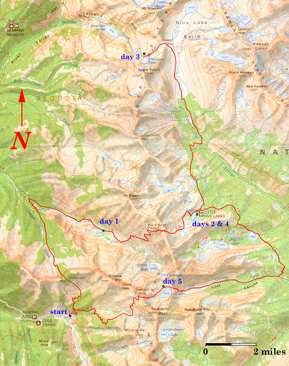
Jeremy and I did a six day backpack in the southern Sierra Nevada of California in June of 1999. That year, my father had been diagnosed with prostate cancer and was scheduled to have surgery in July. While I was waiting for Jeremy to finish last minute pack adjustments, I noticed a Pacific Bell telephone booth near the trailhead at Mineral King. It looked incredibly out of place in that valley surrounded by magestic mountains. I walked over and gave my parents a call. My Dad won't ever venture into the Sierra. It's not because he physically cannot, it has more to do with logistics and my parents' lifestyle and how different we are. I was feeling down about his surgery and decided I'd have to find a way to share my favorite places with him. I put together a personal journal with photos of our trip for Dad to enjoy during his recovery from surgery. The journal is for my dad, but this web version of the trip is for everyone else.
day 1: sawtooth pass trailhead to pinto lake via timber gap This was a somewhat deceptive day due to the up and down nature of the route. The temperature was a cool 65 degrees, but the sun and wind worked hard to suck the moisture out of you. Our packs were at their heaviest and we climbed out of the valley to Timber Gap at 9511 feet. We passed through some nice fields of wildflowers on the way to Timber Gap. I saw blue forget-me-nots, red indian paintbrush, yellow western wallflowers, pink and white alpine phlox and purple mountain bluebells. Blue grouse could be heard booming in the distance as we hiked through the forested areas. Once at Timber Gap, we decended down to 7000 feet where we crossed Cliff Creek. There were mosquitos, a lot of mosquitos. We used DEET sparingly at first, but realized the chemical defense was our only defense on the trail. 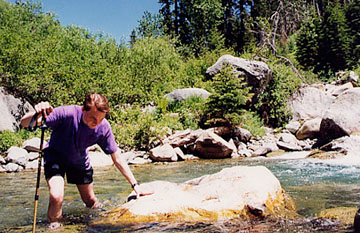
Beyond the creek, the good breeze died off and we were harrassed by mosquitos while partly bushwacking through overgrowth. Here, I'm resting at the base of the falls for which Cliff Creek is named. The wind generated from the falls kept the bugs at bay while we stopped for some gatorade and assessed the climb to Pinto Lake. We hiked up another thousand feet before arriving at the lake where we camped for the night. 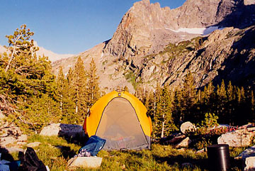
This is our site in the setting sun. Mule deer grazed fearlessly around our camp and we chased them off by shouting and throwing rocks. A marmot was nosing about in the middle of the night until I threw a rock at it. The black plastic canister in the bottom right of the photo is the type of bear canister we use when backpacking in bear country. The national parks in the Sierra provide large metal bear boxes at many backcountry sites for your convenience. However, the canister makes your trip more flexible. We stashed our food in the bear box that night, but this one had a hole in the bottom of it. A mouse got in and chewed through nylon sacks and ziploc bags to sample crackers and nuts. Something else managed to crawl into Jeremy's almost empty backpack and nibble on a science fiction book.
day 2: pinto lake to little five lakes basin via black rock pass We woke early to get a jump on the sun that would be blazing down on us as we climbed up to Black Rock Pass. The mishap the night before with our food delayed us. We started up the pass in the shade of the Great Western Divide, but within 20 minutes it was time to stop and load up on sunblock. Mosquitos were stirring near Pinto Lake, but as we rose on the flanks of the pass, the vegetation gave way to talus and there was little water for mosquitos to hatch from. The winds were steady and strong. The dark rock of the mountain made for a hot hike. We slogged up 3000 feet over most of what was a barren slope. 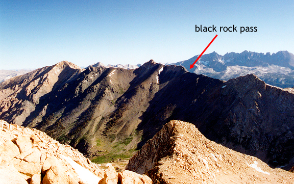
Below is a 360 degree panoramic view from Black Rock Pass (11,630 feet). If you look at me, you are looking south. This is one of the best views I have ever experienced. To the south are three paternoster lakes or staircase lakes carved out by glaciers. Columbine Lake is the highest and drains by waterfall into Cyclamen Lake which drains by waterfall into Spring Lake. Sawtooth Peak (the big pyramid shape) looms above Columbine Lake. Pinto Lake is in the green valley to the west. To the east you can see the Little Five Lakes and Big Five Lakes Basins, the Kaweah Peaks Ridge, Chagoopa Plateau and the Whitney Crest. The winds never let up! 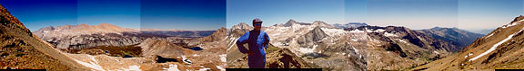
We had a snack and spent an hour with the map identifying what we could see from our vantage point. Then we started down the steep descent to Little Five Lakes Basin. It was only a couple of miles to our lake, but it felt like 5 miles. The slopes were loose with talus and snow was melted out and runoff turned the route into a soggy mess. When we finally reached the lake, we hiked past pools of stagnant water along the shore. Fleets of mosquitos were launching from these pools. We camped on a small peninsula and watched a few other backpackers fishing along the lake. In addition to swarms of mosquitos, we were visited by some curious and comical marmots and Ranger Rob who was stationed at Little Five Lakes Basin for the whole summer to construct a yert for the new backcountry ranger station. His wife, Laura (another backcountry ranger), had issued our backcountry permit, so we told him she said hi. I happily retreated to the tent that evening. It was peak mosquito season at the basin.
day 3: little five lakes basin to precipice lake via big arroyo and kaweah gap In the morning there was no breeze and the mosquitos hovered and patiently rested on our tent. Motivation to get going was low, but Ranger Rob had said that the Big Arroyo was one of his favorite places. That was one of our destinations for the day. What I knew of the Big Arroyo at that time was my only experience with it four years earlier. We had taken a miserable cross country route from Rattlesnake Creek to the Big Arroyo and followed a poorly marked trail along the stream. The bugs were bad, the route was overgrown and the stream crossings were daunting. As far as I was concerned, the Big Arroyo sucked. As we left the basin, we heard a helicopter landing near the lake. It was bringing materials for the yert. We hiked over a spur then down to the Big Arroyo at 9600 feet. 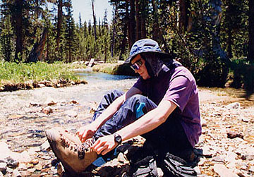
This was the first of many stream crossings for the day requiring a change of footwear. This was not the Big Arroyo I remembered. We were further north of where we had been in 1994 and the valley was wider, sunny and grassy. Just beyond crossing two segments of the arroyo, we took a rest in the shade near a closed down old log cabin ranger station. Jeremy commented how just a few decades ago, it was acceptable for park rangers to come into the wilderness and build a cabin from the raw materials they found there. Now - they fly materials in via helicopter to keep from using up the natural resources of the area. Interesting how attitudes change. 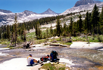
I change into my tevas for our nth crossing of the Big Arroyo. A pleasant breeze came from the head of the large glaciated valley. The walls of the arroyo looked like huge swells captured in granite with sharp peaks dotting the tops. At this crossing, the stream flowed over a granite floor. It felt great to wade through it. 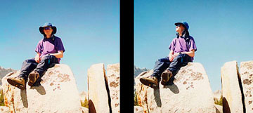
Jeremy checks the weather during a water break. The trail up the Big Arroyo was gradual and pleasant. Jeremy and I pose for a picture (courtesy a boulder) on Kaweah Gap. Nine Lakes Basin and the Kaweahs are behind us. The gap is 300 feet above the valley floor where the trail turns off. 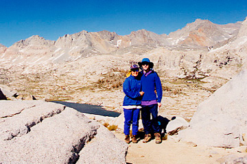
A 180 degree panoramic mosaic from Kaweah Gap (10,700 feet) on the Great Western Divide. To the left is Nine Lake Basin with lake 10,450 in the foreground. The Kaweah Peaks Ridge is in the middle, and the Big Arroyo is to the right. 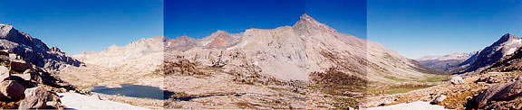
We descended down the other side of Kaweah Gap and passed a few ponds nestled in the boulders. A small avalanche had obliterated part of the trail, but it was easy enough to make our way across the loose rock. We decided to set up camp above Precipice Lake (the top of a chain of paternoster lakes including Hamilton Lake). It took a while to find a spot clear of wet melting snow or large rocks, but wide enough to place our tent. The ledge we settled on had a spectacular view of the Kaweah River Valley. Mosquitos were present, but it was cold enough that they buzzed about in a dull stupor. Below: the view beyond the tent on the left, and on the right, Jeremy prepares dinner. 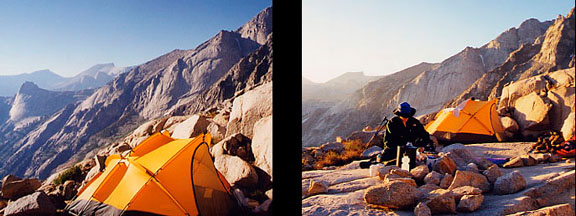
day 4: precipice lake to little five lakes basin Precipice Lake is well-named. These rock cliffs plunge vertically into the lake's edge and the outlet cascades down to feed the next lake in the chain more than 400 feet below. Most of the rocky shore of Precipice Lake was under rotten snow, so we opted not to explore the area. We pumped water at the outlet in the morning. Click on the image for an enlargement. 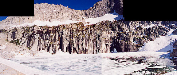
In camp, we had some early morning guests coming by to check us out. In addition to a handful of marmots bumbling about, little mice and a pika raced across the rocks and peeped out loud to one another. We retraced our route from the day before and headed back over Kaweah Gap and south along the Big Arroyo. Our original plan was to backpack up into Nine Lake Basin, but the mosquitos were fierce and in full force which made up our minds to head back. 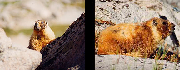
After hiking the Big Arroyo, I understood why Ranger Rob loved it. In the upstream section, the floor is carpeted with grasses and stunted pines. The walls are impressive ridges and the U-shaped valley cradles numerous lakes and a clear, cold running stream of snow melt. I have since changed my opinion and think the Big Arroyo is incredible to hike. It would have been even better in mosquito downtime. We arrived at Little Five Lakes Basin and camped in a different location. The bugs were still going strong, but we had become hardened and relied on DEET every couple of hours. We washed up and enjoyed watching marmots scamper around while we ate dinner. We slept early with the intention to start before sunrise.
day 5: little five lakes basin to columbine lake via lost canyon The full moon made it easy to see while we broke camp. There were two backpackers nearby, so we had to keep as quiet as possible. We began to hike out as dawn set in. We headed south around the arm that separates the Little Five from the Big Five Lakes Basin. We descended into the Big Five which was a complete slog through a marshy mosquito infested basin. We needed to pump water, but the bugs were so bad that we opted to skip water and hike out. When we got to the top of the arm that separates Big Five from Lost Canyon, we rested. It was dry and breezy. We munched on snacks under the shade of two large pines. We drank the last of our water, but the little pond nearby (as indicated on our map) was a muddy cess pool that we didn't want to bother with. We hiked down to Lost Canyon Creek (9550 feet) and pumped a lot of water. 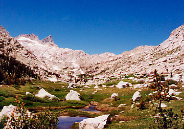
We continued through the woods, following Lost Canyon Creek upstream. As we flirted with treeline, the trees opened up and Sawtooth Peak finally came into view. Lost Canyon is like a miniature version of Big Arroyo. It is also a U-shaped valley, carved out by glaciers with a lush green floor surrounded by towering peaks. Sawtooth is to the left. Many of the boulders are house-sized and scale is difficult to determine because trees are stunted due to harsh weather conditions. The head of the valley stops abruptly at a wall that is a lip bordering the cirque which holds Columbine Lake on the other side. Jeremy stops to take in a breath at the top of the lip (~11,000 feet). Lost Canyon looks very small. Chagoopa Plateau is the dark line behind it, and beyond the plateau is the Whitney Crest. 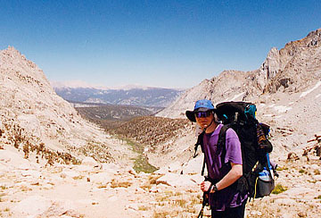
Below is a panoramic shot of Columbine Lake. Jeremy is lounging on a recliner shaped slab of rock. The low point in the distance to the left is the lip that leads down to Lost Canyon. Sawtooth Peak is behind me (the photographer). Columbine is the topmost lake of the paternoster lakes we saw from Black Rock Pass on day 2. Columbine has a few tiny plants growing in crevices where sand can accumulate and along the lake shore. Most of the place is rock and ice. The rock is grippy which makes for great hopping around. 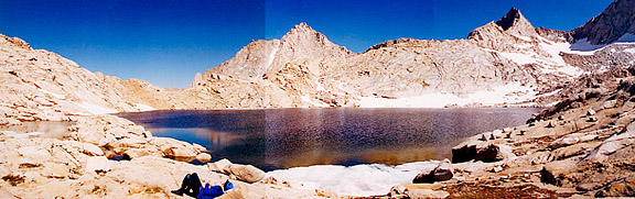
I'm happy to have my boots off, to be at Columbine Lake and to be hiking out the next day! Even without the snow, the reflection of the sunlight off of the rocks was blinding. The lake bottom gets deep very quickly from the shore. The water was absolutely clear, but you couldn't see very far into the lake past a few feet out horizontally. 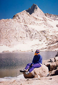
Jeremy rummages through the bear canister for food. We had a lot of left over food since we had planned a 9 day trip (with time to fool around in Nine Lake Basin). Since it was our last night and we were really hungry, we had two dinners. 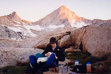
We ate dinner and watched the sun begin to set. The sunlight on the high peaks began to glow with a deepening red hue. We had noticed clouds forming and quickly dissipating behind Black Rock Pass in the late afternoon. We were lucky to enjoy five days without rain or even clouds. By evening there were no clouds in the sky and not a single mosquito to be found. It was too cold for them here. We could enjoy the splendid night sky at our highest camp without being bitten and without trees to obscure the view. I went to sleep, anxious to hike out the next morning.
day 6: columbine lake to sawtooth pass trailhead via sawtooth pass We managed to wake up early and eat a quick breakfast. Breaking down camp took no time at all. We were once again trying to beat the sun, but when we started making our way out of the cirque, the light had begun creeping down the west wall to meet us. This was a cross country route because instead of following the trail - we scrambled over the rocks and boulders following what we thought might be a trail. There are cairns all over the place - so the whole thing could be a giant trail. What is so frustrating is that we did this the first time we were here and we didn't realize our mistake until we had reached the pass and turned around to see this feature winding around below us. 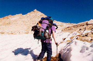
This last panoramic shot is looking west from Sawtooth Pass. Monarch Lake is nestled at the base of the mountains to the left. The trail cuts across the base of Mineral Peak and leads down into Mineral King Valley. Glacier Pass (cross country route) is to the right and is a fast and furious way to get to Little Five Lakes Basin, which is what Ranger Laura did on her days off to go and visit with Ranger Rob. Somewhere down in that green valley was our rental car. 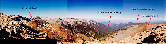
We took the opportunity to explore the ridge and soak in the beautiful views. I finished my roll of film and we set off down the flank of the pass. The last leg out always seems to take longer than you expect. The hike down from Sawtooth Pass is just plain annoying, a lot like riding down a small landslide for a thousand feet. The worst part was coming down sloped boulder surfaces with a good layer of coarse sand on top. We made it to Monarch Lake (~10,600 feet) and continued down into the trees, eventually to the trailhead where another couple was starting their backpack. Driving down into the Sierra foothills, I noticed enormous cumulus clouds billowing up against the mountain front. It was 106 degrees at the Buckeye Flat visitor center, which was packed with sunburned summer tourists looking for parking, campsites and short hikes. We picked up a few books and drove to the freeway. Looking to the east, I saw the anvil shaped thunderheads rising up into the sky, obliterating the southern Sierra. I pointed them out to Jeremy. The fourth of July crowd was in for a ride. |
|
|
|
back to backpacks |
