|
|
|
|
|
soldier lakes basin - august 2003 |
back to backpacks |
|
2 days: 21 miles john muir wilderness/sequoia national park, california august 23-24, 2003 |
|
day 1: cottonwood lakes trailhead to soldier lakes 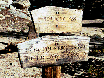
Started hiking at 7 am. Morning was chilly, but the sun was already starting to shine through the trees. We hiked the rolling trail through stands of foxtail pines along the sometimes sandy path. At the first junction, we took a break for snacks and peeked at the map. We took the left fork which crossed Cottonwood Creek and brought us past the north end of the South Fork lakes. 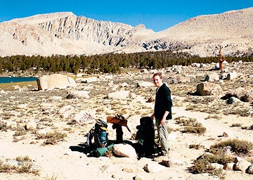
Emerging from treeline, we passed the south shore of Long Lake and could see further down the valley. The headwalls of the basin were very steep and impressive. We continued up the trail to the next bench which cradled High Lake. 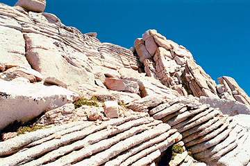
From High Lake it was a series of switchbacks through really cool weathered granite until we topped out unexpectedly soon at New Army Pass. Great views and the flatness of the top were really fascinating. The gentle slopes extended from where we stood and then abruptly dropped off a thousand feet to the basins below. We chatted with a couple that was having lunch on the pass. They were from San Diego and on their honeymoon, to which we gave them a big congratulations and thumbs up. Below: the view from New Army Pass. 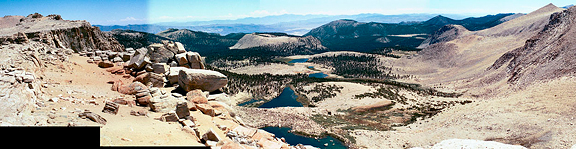
We decided to explore along the edges and walked overland to [Old] Army Pass where we could see some people emerging. The way up to Mount Langley was very clear, and we kept that in mind for a future trip. We found the old trail for Army Pass and followed it down until it intersected the trail from New Army Pass. 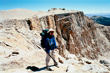
We then descended from the flatlands down some steep switchbacks through what I named "marmot city". The rocky terrain was perfect for marmots, pikas and golden-mantled ground squirrels. We saw a lot of big, fat marmots preparing for winter. A waterfall gurgled at the north end of the cirque and flowed down the valley, fringed with lush vegetation along the entire path. Once at treeline, we took a break for some food. Not far from our lunch stop, we encountered a trail junction and turned north toward Soldier Lakes. We were initially greeted with a large flat meadow, but in another 1/4 mile the lovely lake came into view. 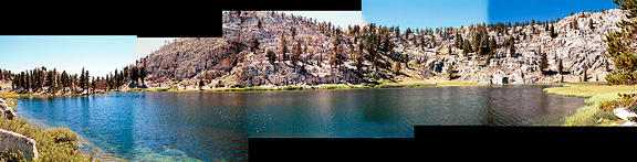
The obvious camp site was already occupied (southern peninsula) so we walked the east bank and found a secluded high camp with good shade. At 2:30 pm we had some lunch on the boulders and then pumped more water from the lake. Jeremy then went to the shore and soaked his feet in the cold water while ducks frolicked close by and I cleaned the dirt out of my trail runners. I took a nap while Jeremy went and explored some off trail routes and clambered up into Miter Basin. When he returned we wandered around the lake to the other side where the trail joined up again. Back in camp we washed up and had our light non-cook dinner in the shade. As the sun began to set behind the western wall of the basin, we saw more fish activity on the lake surface. There was also more activity from the neighboring camp where kids (and adults) were throwing huge rocks into the lake for kicks. We turned in after sunset and debated which route to take back to the car the next day: Cottonwood Pass or Old Army Pass?
day 2: soldier lakes to cottonwood lakes trailhead 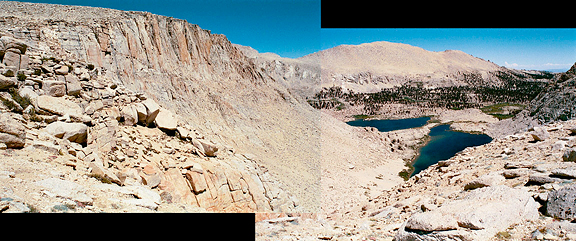
My bladder woke me around 4:30 am and as I stepped out of the tent I noticed that it was warmer than the previous night (actually, the trailheads for Cottonwood Lakes and Cottonwood Pass are always colder than further into the mountains). Looking up, there was a considerable amount of cloud cover which explained the warmth. I could only see a few stars in the sky. I grabbed the bear cannister and returned to the tent. We ate breakfast and then fell back asleep for 30 minutes. The skies changed quickly between partly cloudy to very cloudy. We would have to decide what to do when we could see up valley toward Old Army Pass. We were underway by 6:30 am and skirted the north end of the lake, picking up the trail and hiking out of the meadow to our junction with the Siberian Pass trail. Clouds were moving quickly from the south - monsoon moisture. They seemed to dissipate quite a lot once they passed over the crest, but looking back at the Major General, they piled up into a darker mass. We ate some food and evaluated the situation. We felt strong and so we opted to get over Old Army Pass and high tail it down if the weather looked bad. The whole way up, the clouds poured overhead and evaporated above us, except around the larger peaks like Langley. We reached Old Army Pass by 8 am, stopped for more snacks, pictures and then followed the old trail down. This picture was taken the previous day from Old Army Pass. 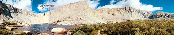
This trail is no longer maintained and there were a couple of places where you had to pick your way over small rockslides across the path. However, it really is in pretty fair condition. At the top of the first lake, we met a young fellow who asked for the time and asked about the weather. He was headed for Langley, dressed in jeans, no watch, no map, a bottle of water, a small pack on his back. Hiking out between the lakes was a treat for the eyes. Clouds continued their march across the sky, but they began to take on that fluffy white Simpsons cloud look and the sky itself was a gorgeous deep blue color. 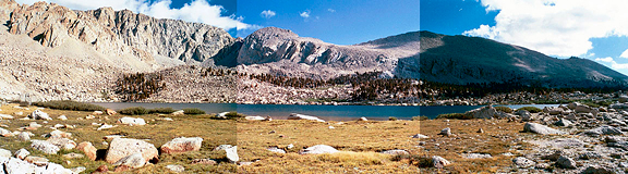
Once out of the lake district, we entered the forest and the trail took on a sort of monotony that occurs when you are hiking out. I didn't remember all of the up-and-down when we had hiked in, the trail was getting hot and dry, and junctions seemed to take much longer to reach than expected. We reached the car by noon and immediately loaded the car, changed our clothes and drove down to Lone Pine for some lunch. On the drive down, there were some impressive dark thunderheads moving in from the south - that in contrast to the glaring brightness of the Owens Valley floor filled with evaporites of multiple colors. As always, we were happy to be done with the trip. All the way down to Lone Pine, we would look back at the Sierra Crest and plan for the next trip in. |
|
|
|
back to backpacks |
