|
|
|
|
|
northern presidentials - july 2000 |
back to backpacks |
|
3 days: 18 miles white mountains national forest, new hampshire july 23-25, 2000 |
|
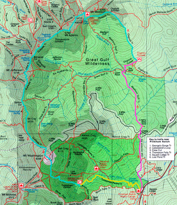
Jeremy and I planned this trip as a training run for our upcoming backpack in the Sierra Nevada in August. Having hiked here once before, I was moderately familiar with the terrain to expect. We intentionally wanted day 2 to be a challenge, and it certainly was. Below is a map of our route. Day 1 is in yellow, day 2 is colored blue and day 3 is outlined in pink. Our only deviation from the original route was to skip Mt. Madison and take the Parapet trail around the south side of the mountain (big mistake - see trip log below). I would recommend getting a copy of the AMC White Mountain Guide which allowed us to research and plan our trip rather painlessly. They include a series of topographic maps in the book which we used on trail. Definitely call the nearest center for trail information and conditions. Part of our route was undergoing maintenance and would be closed for certain days which was helpful to find out BEFORE driving 9 hours to the trailhead. I was told that the water in the White Mountains had to be filtered for giardia, other bacteria, viruses, and "other" contaminants. Luckily, there was potable water available at a number of stops (Pinkham Notch, Hermit Lake, Mt. Washington, Madison Hut). The most important factor in our trip was watching the weather forecast. We basically needed a single day window of good weather to traverse the ridge. When we left Ithaca, it was forecasted to be sunny the next day. When we hiked to Mt. Washington the next morning, there were orographic clouds hugging the ridge. Fortunately, the high pressure system stayed around while a low pressure system off the coast threw just enough moisture to form clouds, but not enough to bring rain and thunderheads. It helps to be in good shape which makes the difference between a good trip and torture. Finally, use common sense (this applies where ever you go, but especially in the mountains).
day 1: pinkham notch visitor center to hermit lake shelters It took us about 9 hours to get from Ithaca to the Pinkham Notch Visitor Center. At the visitor center we purchased a parking permit for 1 week ($5) and also paid for our night stay at the Hermit Lake Shelter ($8 per person per night). As you leave the visitor center main entrance, the trailhead for Tuckerman Ravine is clearly marked to the right. We left at 5:00 pm and got to the camp by 6:20 pm. The whole way up we passed dozens of day hikers and some backpackers coming down the trail. The trail, which used to be an old tractor road, is wide and riddled with large rocks. It climbs moderately steeply through the trees and we made fast progress to the lake. There are eight shelters and three tent platforms at Hermit Lake (when you get to the caretaker hut, the trail veering to the right leads you to the campsites). There is potable water available and they even have new flush toilets which were nicer than some of the toilets you find at highway rest stops. It's all quite cushy. I was amazed to find you could purchase t-shirts, nalgenes, powerbars, mugs, gatorade, etc. at the caretaker hut. 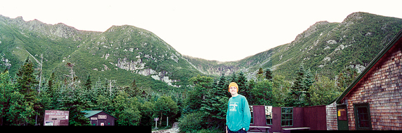
Jeremy patiently poses for a panoramic shot of Tuckerman Ravine from the caretaker hut. We nabbed the last tent platform. Here, Jeremy is changing into some warmer clothes after setting up the tent. Red squirrels were active and suspending your food was recommended. Unaware that Hermit Lake would have potable water, we carried enough to last us through Washington - but we gladly filled up given the chance. Patchy clouds drifted in and out, then as night fell, the air temperature cooled and the katabatic off of Washington flowed over the ravine. It was humid - none of our stuff dried out. I am guessing the low reached 50 F or so. It was pleasant. 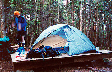
day 2: hermit lake shelters to osgood tentsite This day was a good test of mettle and endurance. We rose early and left camp at 6:45 am. The sun was shining brightly and slowly making its way across Tuckerman Ravine as it climbed the sky. The trail wound through the trees which became more stunted the higher we went. The people who built and maintain these trails put an enormous amount of effort into it. 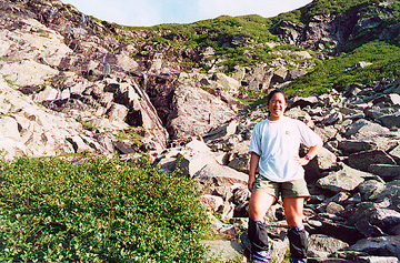
The Tuckerman Ravine trail is well constructed with lots of block stones placed almost like stairs in some stretches. Arriving at the lip of the cirque, we were afforded a splendid view of the headwall which was green with vegetation. Tiny cascades of water streamed down over the vertical rocks. I posed for a quick picture during a water break on our way to the top of the ravine. 
It was not long before we arrived at Tuckerman Junction. This is a view looking south toward Mt. Monroe. Down to my right is Tuckerman Ravine. We headed up the cone of Mt. Washington over its rocky south slope. Upon our arrival at the summit (9:00 am), we were greeted by the annoyingly loud cog rail, the equally loud tourists and the auto road. Mt. Washington was a most depressing experience for me. We filled water, ate some food and winced at the hordes of people around us. We did take advantage of the weather report and checked on the most recent updates. Apparently the clouds we saw creeping in along the range would be there throughout the day with low probability of rain or thunderstorms. 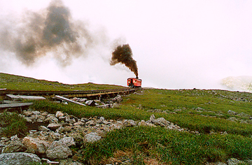
We set off for the Gulfside Trail via the Trinity Connector. If I ever go that way again - I would opt for the Crawford Path to the Gulfside instead because it's a real path rather than a bunch of cairns on a pile of rocks. When the two trails join before the junction with the Gulfside Trail, you end up hiking over the cog rail tracks. I took this picture to show how much black smoke the offensively loud cog rail spews into the air. The people on the train waved at us as they went past. 
From this point on, we encountered many day hikers, backpackers and thru hikers on the trail. Views of the Great Gulf were most impressive and so was the ridge of the northern Presidentials stretching around to the north as shown in the photo above. 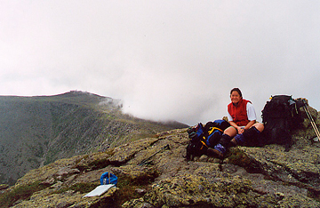
We followed the Gulfside Trail with the summit options and the route had the characteristic of a rocky dirt path along low points and predominantly boulder field crossings on the summits. Going up anything was not a problem, but descents off the summits were difficult at first, then punishing with each additional summit. Mt. Clay was mild and we took a break for moleskin, photos, food and water. We were actually thankful for the clouds overhead because the sun would occasionally peek out and we'd quickly feel overheated. Wispy white clouds draped over Madison, but to the east and west the cloud deck was spotty and nothing threatening loomed in the distance. Above is a 270 panoramic from Mt. Clay. Jeremy is to the west. Mt. Washington is south and looking north you see Mt. Jefferson. 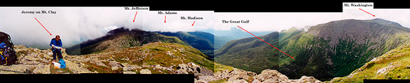
We watched closely in case we needed to alter our plans. From Clay we descended to Sphinx Col where we chatted with a few thru hikers and continued up to Mt. Jefferson. The trail leading up to Jefferson was pleasantly easy and we met a few day hikers having lunch near the summit. We were hungry, but thought we'd rest after the descent from Jefferson since that seemed to tire us out more than the climbs. Just past the summit we took a short break for water and assessing the route on the map. Here's Jeremy in front of the dramatic Jefferson Ravine that plunges to the east with Adams in the distance. 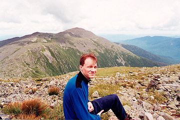
Jeremy was considering skipping Adams in favor of Madison, but I thought Adams would be worthwhile to see. So we agreed to decide when we got to the turnoff. We hiked down to Edmand's Col. The col itself is a striking feature - as good as the view it affords of the Great Gulf. Many hikers were breaking here for lunch so we moved up the extensive southern arm of the Adams triad before breaking for our calorie packed meal. Jeremy took a picture of me enjoying our trailside break before hiking up to Adams. 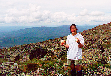
The climb up to Adams wasn't so bad, but the summit experience was just plain gross. There had been flies throughout the trip, but they just milled about you without any fierce attacks. On Adams, there were clouds of flies in a frenzy that you only expect to see when there is an open pit toilet around. The summit has nothing aesthetically pleasing to offer unless you look away from it or start to walk away from it. The descent down Adams felt bad. Maybe because we were getting tired, or maybe because that trail (if you call it a trail) sucks. We made our way down the talus to the Gulfside Trail junction and carried on to the AMC run Madison Hut. There we filled up on water (no reliable water at Osgood) and had some snacks. It was 5 pm and we were feeling tired, sweaty and hungry. In what we thought was a good alternative, we decided to forget about Mt. Madison and take a contouring trail around the south side of Madison instead. This is the Parapet Trail. The distance was just slightly longer, but we wouldn't have to do the descent down from the summit. It's too bad we didn't have that part of the trail description with us because that trail was pure evil and the wise AMC guide said to take that trail only in the event that you'll be blown off of Madison summit during a storm. It took us 2 hours to travel that 1.1 mile stretch. It is overgrown with (strong) stunted trees and is riddled with large sloping boulders that are difficult to negotiate with a pack. By the time we reached the Osgood Junction, we had little energy and less than 2 hours of light left to reach camp. The Osgood Trail is deceptive when just looking at the map. It appears to be steep but manageable. From Osgood junction, it begins as a series of steps down the ridge over rocks and some dirt trail. You gradually reach treeline and then it really gets going on its elevation loss - still rocky, but now rooty and very steep. I doubt it's too enjoyable when you are fresh, but after 9 miles of up and down all day long, I was really feeling it in my feet (the blisters on my feet) and my knees. By the time we began expecting to see signs for the campsite, light was failing and our progress slowed to accomodate the darkness. At one point Jeremy was sure the camp couldn't be much further and he dropped his pack on the trail (by a potential bivy site) and ran ahead with my pack while I followed. After 10 minutes he came back up the trail and said he was going back for his pack and that he hadn't found the junction yet. I went ahead and got my pack and continued on. It was completely dark by now and we were hiking with headlamps. There are a few deer trails that branch from the main trail which in daylight you probably wouldn't think twice about - but at night it made you wonder if THAT was the trail. Luckily, the Osgood is well marked with white blazes. The trees on the trail also have flaps of white bark just about everywhere which often were mistaken for blazes or possibly the sign indicating camp. I waited for Jeremy when the trail began to level out and he caught up with me within 10 minutes. I felt like I had traveled more than the 2 miles to our turnoff and the thought that we had somehow missed our junction hung in the back of my mind. Hiking another 15 minutes finally brought the sight of trail signs, although we were prepared to bivy on the trail soon. Hiking into the campsite, we found the platforms (all 3 of them) were full and the choice bare ground spots were also occupied. We made do with a tiny space on a slope and set up our tent, crawled in and administered to our blisters. There was talk among the campers that a bear had bluff charged two of the hikers (they had passed me on the trail in the dark a few minutes before Jeremy caught up) right after they had talked to me. I was hungry, but I was more tired than hungry. It had been 15 hours on the trail and I was thrilled just to be off my feet. Looking up from the ground, I looked at the night sky for the first time that evening and saw stars through the mesh roof. It was a warm night (55 F) and crystal clear. I fell asleep exhausted with thoughts of a bear lumbering around camp.
day 3: osgood tentsite to pinkham notch visito center In the morning, we were greeted by a thru hiker dog who was on her way with her people from Maine to Springer Mt. in Georgia. Our blisters had recovered in the night and our knees were stiff but not damaged. We packed up, anxious to get to the car and drive home. We left camp at 7:00. The area looked completely different in daylight. We took the Osgood Cutoff to the Madison Gulf Trail and both of these routes roll up and down muddy and rocky trails crossing many ephemeral (but wet) streams. Flies were buzzing, but not biting (unless you stopped long enough) and it was getting warm quickly. The Madison Gulf trail starts to climb up (still rolling up and down) to a short side trail leading to Lowe's Bald Spot with a few interesting slab crossings on the way. I would have considered these fun if I hadn't been so fatigued from the previous day. Shortly after the Bald Spot junction, we were spat out onto the dreaded Mt. Washington Auto Road at mile 2. We took a break at the small roadside parking lot and snacked up. Old Jackson Road was the last leg of our hike back to Pinkham Notch, just 1.9 miles left. Thoughts that the trail used to be a road convinced me that the trail would get better - easier on the legs. Of course, I had my suspicions too. The first half mile could not have been a road for anything except a tank, but then the trail does become more tame and softer underfoot. We got to Pinkham Notch by 10:30 and drove home from there. There were no pictures taken since Mt. Adams, but the experience is certainly carved into our memories. The 9 hours on the road gave our legs ample time to stiffen up nicely. All in all, a good hard trip.
|
|
|
|
back to backpacks |
